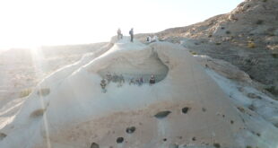
Days: 2 Days Rating: (Moderate/Strenuous) Milage: 10 + Elevation Gain/lost: +1400 Location: Anza Borrego Desert Trail Head: 32.77906, -116.09002 Type: In & Out Gaiagps Map Google Map:
Read More »Domeland WindCaves
Days: 2 Days Rating: (Moderate/Strenuous) Milage: 10 + Elevation Gain/lost: +1400 Location: Anza Borrego Desert Trail Head: 32.77906, -116.09002 Type: In & Out Gaiagps Map Google Map:
Read More »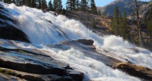
Days: 2-3 Days Rating: (Moderate/Strenuous) Milage: 20 + Elevation Gain/lost: +2380’/-1490″ Max Elevation : 4,700′ Min Elevation: 294′ Location: Big Sur Trail Head: 36.246075, -121.780149 Type: Loop GPX File Download Sykes Hot Springs is a popular hiking destination in the Ventana Wilderness. The actual springs are farther down the creek than one is led to believe in a few of the guidebooks. Sykes Hot Springs has stone lined natural tubs that …
Read More »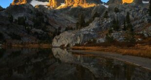
Days: 5-6 Rating: (Moderate/Strenuous) Milage: 60+ Elevation Gain/loss: +12,365’/-13,789″ Max Elev : 11,074′ Min Elev: 4,200′ Location: Devil Postpile Trail Head: 37.630365, -119.084872 Type: Point to Point Trail Map Googe Earth Map PDF Map GPX Download Itinerary July 9 – 16 Day 1 Devils Postpile to Garnet Lake Milage: 11.2 Ascent: +3908 Descent: -1704 Max Elev: 10,094′ Min Elev: 7561′ Elevation Graph Map >>> Day 2 Garnet Lake to Rush Creek Trail Milage: 5 Ascent: +1061 …
Read More »
Days: 2 Rating: (Moderate) Milage: 12 + Elevation Gain/loss:+900 to 1500″ Max Elevation :9,300′ + Min Elevation: 8,037′ Location: Sierra National Forrest Trail Head: 37.528724, -119.440662 Type: In & Out: MAP: Link Google Earth/TOPO Map GPX File Download Chain Lakes is a series of three lakes located in the South Eastern region of Yosemite National Park near the border of the Sierra National Forest. The hiking trail …
Read More »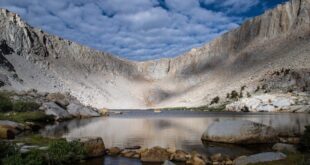
Days: 2-3 Days Rating: (Moderate/Strenuous) Milage: 21 + Elevation Gain/lost: +4550’/-2400″ Max Elevation : 14,026′ Min Elevation: 10,036′ Location: Horseshoe Meadow Trail Head: 36.448321, -118.170684 Type: In & Out Topo/Map Google Map: GPX File Download Mount Langley is located on the crest of the Sierra Nevada, on the boundary between Inyo and Tulare counties, in eastern California in the southwestern United States. To the east is Owens Valley, and to the west is the Kern River Valley. It is the ninth highest …
Read More »
Days: 3-4 Days Rating: (Moderate/Strenuous) Milage: 27 + Elevation Gain/lost: +6688’/-5954″ Max Elevation : 6,681′ Min Elevation: 4,254′ Location: White Wolf (Tuolumne – Yosemite) Trail Head: 37.876913, -119.345723 Type: oneway Topo/Map Google Map: GPX File Download Grand Canyon of the Tuolumne The Grand Canyon of the Tuolumne is Yosemite’s more wild, less crowded little sister. Because its amazing cliffs and beauty is less accessible, those willing to make the effort are …
Read More »
Days: 3-4 Days Rating: (Moderate/Strenuous) Milage: 27 + Elevation Gain/lost: +6193’/-10864″ Location: Lyell Canyon Trailhead Trail Head: 37.877371, -119.337989 Type: oneway Google Map:<<click here>> GPX File Download Vogelsang Pass >> Rafferty Creek >> Cathedral Lakes >> Tuolumne Meadow is just that; an enormous meadow, very beautiful, but even more so in the spring with the wild flowers. Highway 120 goes through the area, a paved road in very good condition. Bear …
Read More »
Miles: 15 +/-miles Days: 3 days, 2 nights Elevation Gain/Loss: 2779’/1213 Max Elevation: 11974′ Min Elevation: 9429′ Type of Trip: Backpacking Difficulty: Moderate/Strenuous Location: Inyo/Kings Canyon About Bishop Pass & Dusy Basin The trail to Bishop Pass is one of the great hikes on the southeast side of the Sierras. The trail leads through a succession of beautiful lake basins …
Read More »
Miles: 22 +/-miles Days: 3 days, 2 nights (1-day car camping) Elevation Gain/Loss: 6124/9838 Max Elevation: 8606 Min Elevation: 4042′ Type of Trip: Backpacking Difficulty: Moderate/Strenuous Location: Yosemite GPX: Download Google Maps: >>Link<< Trails The Pohono Trail This east-west hike along Yosemite Valley’s south rim, going from Glacier Point to the Tunnel View (or, less frequently, vice versa), is >>more info<< The Panorama Trail Two of Yosemite’s most spectacular hikes, Glacier Point and the Mist …
Read More »